yes, so what exactly did I learn about afforestation and deforestation affecting the shape of the storm hydrograph, based on the water balance equation? Allow me to give an outdated post dedicated to it. =D
Note: In case you forgot aboutit, the water balance equation is:
P (Precipitation) = Q (Total streamflow) + E (Evapotranspiration) + (change in) Storage in bedrock and soil
(If its a whole lot of jargon, then you are not 08ip06.)
1. Afforestation
Q decreases: Due to the presence of more trees, interception increases and reduces the amount of water available in the system. This is also due to the fact that the infiltration capacity of the water increasing, and more water can be absorbed into the soil.
As such,
S increases.
E increases: As there are more trees in the area, there are more leaf coverage over the water flowing. Hence, evaporation levels are reduced. Secondly, due to the presence of trees, transpiration occurs at a higher rate.
2. Deforestation
Q increases: This is due to the fact that there is a lack of trees and agriculture in the area, and these actually allow the water to seep into the soil, reducing the amount of water that reaches the river. Hence, in the absence of tress and agriculture, it allows overland flow to occur, allowing the water to reach the river faster. Thus, Q increases. =D
E decreases: (refer to above)
S decreases: This is due to the fact that water takes a longer time to permeate into the soil, reducing the infiltration capacity of the soil and reducing the amount of water that will enter the soil and stored.
So there you go! =D
-marcus (17) JH406
Thursday, June 25, 2009
Monday, June 8, 2009
Rapids
What are rapids? Rapids is a land form predominantly seen on the upper course of the river where there is little energy in the stream and thus having little erosion capability. Rapids occur when there river bed which the stream flows over is made out of an alternating band of rock. These rocks are made of different minerals and have different densities, thus they would be eroded by the water at a different pace. The many alternating bands of differential erosion causes the river bed to rise and drop erratically, and where the stream drops from a more resistant rock band to a lower resistant rock band, the change in gradient causes an increase of velocity in the stream.
The formation of rapids is highly similar to that of a waterfall but the difference lies in the ease of erosion of the rock bands as well as the amount of alternating rock bands. The formation of rapids can also be caused my numerous large boulders or rocks that stick out above the stream surface and is hardly eroded due to the insufficient energy of the stream. These boulders create much friction for the stream and bubbles are mixed into portions of the stream causing the appearance of "white water".

-ervin JH406 (16)
Sunday, June 7, 2009
DELTAS
Deltas
So what exactly is a delta? A delta is a landform that is found at the lower course of the river, where the river flows into the oceans/seas. Deltas are formed from the deposition of the sediment carried by the river as the flow leaves the mouth of the river. River deltas form when a river carrying sediment reaches a body of standing water, such as a lake, ocean, or reservoir. When the flow enters the standing water, it is no longer confined to its channel and expands in width. This flow expansion results in a sudden decrease in the flow velocity, which diminishes the ability of the flow to transport sediments. As the velocity of the river is low, and the river have little energy left after constant erosion of the soil and the new environment that the water current is in, deposition would occur, causing boulders, rocks and pebbles to drop. When the river energy is really low, even sand, and smaller eroded particles would be deposited. Over time, all these deposition would form a landform, a piece of land, which is called the Delta.

Luke.
Friday, June 5, 2009
Hello everyone!
Here's the summary post.
So we started this module looking at the big picture, the atmosphere.
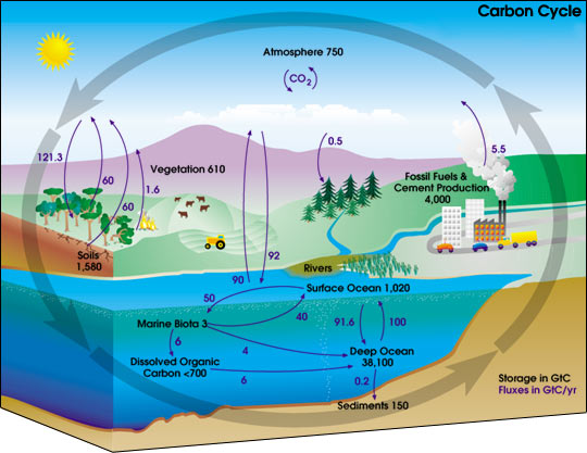
We studied the many layers of the atmosphere, the composition of air in the atmosphere as well as some of the important cycles that take place around us - the carbon cycle and the nitrogen cycle. We also learnt about the ozone layer, and its importance in sustaining life on Earth.
We then studied the importance of the Sun, and learned about the Planetary Heat Balance, which ensures a steady level of heat on Earth. We learned how the heat was divided up into longwave and shortwave radiation, and the proportions in which it is divided. We also learned about seasons, and how they are formed by the revolution of the Earth around the Sun.
We then moved on to air and wind, where we learned the 3-cell model and different wind patterns. We observed the model's relation to the formation of natural features, such as deserts. We also started learning about climates here, and the many different kinds of climates that exist. We also learned how to analyse a climograph, and to describe the climate of an area with regard to the level of precipitation, and temperature range.
We ended the Atmosphere section with the study of clouds and rain. We learned the formation of clouds by adiabatic cooling, and the 3 kinds of rain that exist. The concept of clouds and rain also provided a base from which to begin the Hydrosphere half of the module.
The hydrosphere half was certainly content-heavy. We started with the study of the water cycle. This is something all of us were familiar with from primary school, but now, we learned the more in-depth terms used to describe the various processes, such as interception, percolation, and throughflow. We studied the flow of water from the time it is precipitated as rain or snow, to the time it joins the river channel to be carried to the sea. We then moved on to the water balance equation and hydrographs, both of which enable us to see the changes in the amount of water flowing in a river. We then observed how changes made by humans could affect the water balance equation and hydrograph of a river. We studied the changes made by the introduction of agriculture, urban features as well as deforestation.
We then moved on to the study of the rivr itself. We studied the characteristics of the upper, middle and lower course of the river, noting the shape of the channel, velocity of the water as well as the processes that occur at the specific areas. With the knowledge of the processes of erosion, transportation and deposition, we were then able to understand how specific features such as waterfalls, meanders, floodplains and deltas are formed at the specific areas of the river.
With that, we end our module, with a project remaining for us to present after these holidays. The project, involving river management, will certainly help us realise how significantly human activity impacts the river and its contents.
So there's a short (HAHAHA) summary of this module!
;D
your ever-efficient (HAHAHA!) blogmistress,
-aditi.
Here's the summary post.
So we started this module looking at the big picture, the atmosphere.
We studied the many layers of the atmosphere, the composition of air in the atmosphere as well as some of the important cycles that take place around us - the carbon cycle and the nitrogen cycle. We also learnt about the ozone layer, and its importance in sustaining life on Earth.
We then studied the importance of the Sun, and learned about the Planetary Heat Balance, which ensures a steady level of heat on Earth. We learned how the heat was divided up into longwave and shortwave radiation, and the proportions in which it is divided. We also learned about seasons, and how they are formed by the revolution of the Earth around the Sun.
We then moved on to air and wind, where we learned the 3-cell model and different wind patterns. We observed the model's relation to the formation of natural features, such as deserts. We also started learning about climates here, and the many different kinds of climates that exist. We also learned how to analyse a climograph, and to describe the climate of an area with regard to the level of precipitation, and temperature range.
We ended the Atmosphere section with the study of clouds and rain. We learned the formation of clouds by adiabatic cooling, and the 3 kinds of rain that exist. The concept of clouds and rain also provided a base from which to begin the Hydrosphere half of the module.
The hydrosphere half was certainly content-heavy. We started with the study of the water cycle. This is something all of us were familiar with from primary school, but now, we learned the more in-depth terms used to describe the various processes, such as interception, percolation, and throughflow. We studied the flow of water from the time it is precipitated as rain or snow, to the time it joins the river channel to be carried to the sea. We then moved on to the water balance equation and hydrographs, both of which enable us to see the changes in the amount of water flowing in a river. We then observed how changes made by humans could affect the water balance equation and hydrograph of a river. We studied the changes made by the introduction of agriculture, urban features as well as deforestation.
We then moved on to the study of the rivr itself. We studied the characteristics of the upper, middle and lower course of the river, noting the shape of the channel, velocity of the water as well as the processes that occur at the specific areas. With the knowledge of the processes of erosion, transportation and deposition, we were then able to understand how specific features such as waterfalls, meanders, floodplains and deltas are formed at the specific areas of the river.
With that, we end our module, with a project remaining for us to present after these holidays. The project, involving river management, will certainly help us realise how significantly human activity impacts the river and its contents.
So there's a short (HAHAHA) summary of this module!
;D
your ever-efficient (HAHAHA!) blogmistress,
-aditi.
Hydrographs
 Ok, firstly, hydrographs are graphs which show river discharge over a given period of time and show the response of a drainage basin and its river to a period of rainfall.
The discharge of the river is calculated in cumecs/cm^3.
Secondly, 2 most important things we must take note of a hydrograph are the lag time and the shape of the graph.
Lag time is the time between the peak rainfall to peak discharge, as stated in the diagram above.
Factors which affect the lag time are:
1. vegetation
2. humidity
3. precipitation
4. relief of drainage basin
5. overland flow [ water flowes fastest ]
6. through flow/ groundwater flow [ water flows slowest ]
These factors determine the speed at which water reaches the river.
A shorter lag time will mean that water had flowed quickly to the river.
A longer lag time will mean that had flowed slowly to the river.
A steep or gentle gradient will result from the duration of the lag time and affect the shape of the graph.
Steep: Short lag time, higher peaks
Gentle : Long lag time, lower peaks
Factors which affect the shape of the graph are:
1. Geology of the drainage basin [ Eg. impermeable or permeable bedrock ]
2. Distance between infiltration and the river
Examples:
Urbanisation
In urbanised areas, vegetation has been replaced by tarmac and cement surfaces. This will prevent infiltration of precipitation into the soil, resulting in significant overland flow. In addition, complex drainage and pipe systems in these urbanised areas will increase interception of precipitation. Hence, precipitation will be transported quickly to the river, decreasing the lag time, resulting in a steep sloped hydrograph.
The same goes for grazing and deforestation. In these 2 other examples, vegetation has also been removed. Hence infiltration and interception of precipitation will decrease and surface run-off will increase. A steep-sloped hydropgraph will result as well.
Afforestation
In afforested areas, vegetation is present. Infiltration will increase as the roots of the plants provide pathways for precipitation to percolate underground. Interception [ stem flow and through fall] will increase as well. In addition, evapotransiration will occur. When these happen, lag time will increase as precipitation takes a longer time to reach the river and thus giving a gentle sloped hydrpgraph.
Our lovely IS2104 hydrosphere booklet
That's all!
The end:):):)
Wednesday, June 3, 2009
Shapes Of Valleys Formed At Various River Courses
 Heyho(:
 This blog entry is to basically help you understand more about the shape of the valleys formed at the upper course, the middle course and the lower course.
The river is generally divided into three courses, the upper course, the middle course and the lower course. And this is due to the rate of erosion and deposition occurring at each course and other factors, which have been described below, and therefore, valleys are formed.
The upper course of the river is usually the young part of the river, usually where the flow of water begins from or also known as the river mouth. The middle course is known as the mature stage and the lower course is as such known as the old stage of the river.
The Upper Course
The upper course is located usually at the top of the river and has the steepest gradient compared to the other parts of the river. Therefore, water flows quickly through the channel and over time, the sides of the channel get weakened by weathering processes and erosion occurs in a downwards direction. It is also known as vertical erosion. Slowly, the mass movement of materials occurs down the valley sides and creates a v-shape. Vertical erosion is the cause many other landforms and for the steep sloping v-shaped valley formed at the upper course. Vertical erosion usually occurs in form of abrasion, hydraulic action and solution. The overall energy present for vertical erosion to take place is very high and more than lateral erosion and as such, the river continues to cut down vertically. Also, very little deposition takes place at the upper course.
Middle Course
Middle Course
In the middle course, the river channel becomes wider and deeper as the river, as the channel has been eroded and it is also due to the many tributaries that have begun to branch out from the river. The velocity of the water flowing in the middle course is decreased as compared to the upper course as the gradient is lesser steep. Therefore, the surrounding valley has become wider and flatter and additionally, there is a more extensive floodplain present. Due to the unique pattern of erosion and deposition and bends in the middle course of a river, landforms such as meanders, slip-off slopes and oxbow lakes are formed. Wider lakes can also be found at the middle course of the river.
Lower Course
At the lower course of the river, water begins to run even more slowly as the gradient of the river becomes lesser steep. Therefore, lesser erosion and more deposition takes place. Usually a wide floodplain is formed here as such. And floodplains are also formed when there is a heavy rain and the river’s water level rises and the average speed of water flowing increases. And that causes the deposited material or other fine material to be in suspension. Then, due to the increased speed of water, the river overflows its banks and deposits its load. And slowly, a small layer of load is laid at both sides of the river. The layer of load or material is also known as alluvium and this eventually forms a level of land called a floodplain. The shape of the valley in a lower course river is usually the widest and in a u-shape.
Definitions of some of the key words used above:
Erosion: The group of natural processes, including weathering, dissolution, abrasion, corrosion, and transportation, by which material is worn away from the earth's surface.
Deposition: The act of depositing, especially the laying down of matter by a natural process.
Tributaries: A small river which eventually joins or branches out from the main river.
Floodplain: A flood plain is a level stretch of land found on both sides of a river in its mature and oldstages.
Done by:
Subha(:
jh406.08
Tuesday, June 2, 2009
Transportation in River Channels
HELLO!! EVERYONE.
I will be blog on one kind of river channel processes--Transportation.
Rivers have energy. (As a reminder, rivers' energy come from two sources--kinetic energy as well as potentional energy. Thus the factors affect the energy of a river are, just to name a few: gradient of land, roughness of channel, shape of channel cross-section, volume of river...etc) After successfully overcoming friction, energy is used to carry or transport eroded materials such as mud, sand, boulders and dissolved materials. These materials are called its load. River transport their load by four processes. These processes are traction, saltation, suspension and solution.
Traction: larger particles like pebbles and boulders roll and slide along the river bed. They move only if the speed of the river is great enough to move them. Some of them are so heavy that they can only be rolled along during heavy flooding.
Saltation: large particles such as gravel and coarse sand are lifted and dropped along the river, so they bounce along the river bed in a series of bed.
Together, the saltation load and the traction load form the bedload.
Suspension: fine particles such as clay, silt and fine sand are carried along without contact with the river bed. Materials carried in suspension(suspension load) usually forms the greatest part of the total river load and this exlains why most rivers look muddy.
Solution: soluble minerals(dissolved load) in the rocks such as salts of calcium and sodium are carried away in solution . Trying to look out for these type of load in a river? Too bad, they cannot be seen by a naked eye. Solution occurs even when the speed of the river and its volume of water are low.
Yup:) So that's all about trasportation. If you are unsatisfied, or still get something unclear, ahha, then maybe you would like to watch this short yet cute video about river transportation:
http://www.youtube.com/watch?v=IhWrn6ys1Wc
IS2104 is over, yet I think (Physical) Geography should not end here. Geography is both useful and interesting. USA's 35th president Joh F. Kennedy said" Geography has made us neighbours." And believe it or not(don't believe it), famous scientist Albert Einstein said:""As a young man, my fondest dream was to become a geographer. However, while working in the customs office I thought deeply about the matter and concluded it was too difficult a subject. With some reluctance I then turned to physics as a substitute."-----Actually this is a blunder, to find out more, visit this http://geography.about.com/od/geographyglossarye/g/ggeinstein.htm
I think (Physical) Geography is not about maps, nor about memorisation of facts. The learning of Geography to a certain extent is about learing our home--the Earth.
Done by Cao Li :) JH406(13)
Floodplains and Levees
Floodplains
A floodplain is a flat area of land bordering a river that is subjected to periodic flooding. It is made up of silts and sands which have been deposited oever many years by the river.
When the river floods over the surrounding land it loses energy and deposits its suspended load. Regular flooding results in the building up of layers of nutrient which forms a flat and fertile floodplains.
Levees
A raised river bank building up by deposition of the river during flooding period.
When the river water burst its bank, the water loses its energy and therefore deposit occurs. The heaviest materials are deposited first as these required most energy to be transported and therefore build up around the sides of the river forming raised banks known as levees.
Done by Frank JH406 (19)
Monday, June 1, 2009
MEANDERS!!!
Alright, let's start off by refreshing your memory of what a meander is. In simple terms, a meander is a feature of a river, at where there is a bend in the river course. Meanders are formed by mainly 2 processes, namely deposition and erosion.


Flow of fastest water, Thalweg, swings from bank to bank, and when it hits the outer bend, erosion occur due to hydraulic action, resulting in the undercutting of the river bank, forming a steep sided river cliff, a concave bank. This can be observed in the cross section diagram below.

Next, due to the helicoidal flow of water in the meander, sediments are brought to the inner bend, and water being slow flowing at the inner bend deposits the sediments, forming a slip off slope, a convex bank.
Overtime, the convex and concave bank would be more obvious, thus showing the bends in a river course - a.k.a MEANDERS!
An example is the stretch of River Conwy in the North Wales, which use to be a river in the past, but now having complex pattern of meandering.
Overtime, meanders actually leads to the formation of an Ox Bow lake too. As we have learnt that erosion takes place on the outer bend, it causes the neck of the meander to become narrower, and eventually joining together. Water will then takes the shortest route, which is the straight river course without passing through the meander bend. after some time, deposition will then seal off the old meander bend, forming a straight river channel. The old meander bend that is left isolated will be called an ox bow lake!
Sean Quek
JH406.21
Effects of Agricultural and Grazing on Water Balance and Hydrograph (Pham Minh Tri)
1. Water balance:
P=E+Q+deltaS
P= Precipitation
E=Evapotranspiration
Q=Run off.
deltaS=Change in storage.
Basically, water balance is just an expression of the idea of conservation of water: If there is water precipitated, that amount of water has to either evaporate back or run off to somewhere else.
2. What we do in agriculture and how that affects water balance:
Assume that the considered land was previously a forest, what we do is basically to chop down all the trees and vegetate the land with crops. To determine how that affects various factors in the water balance, let's make further assumption that the previous concentrated forest is replaced by corn. Based on that assumption, evapotranspiration will obviously drops since the ability to intercept and hold water of the concentrated forest is much better than the corn field. Hence E drops.
Through agricultural activity, the surface soil may be soften and made more spongy. However, as the vegetation layer is much thinner than before, this surface soil is easily washed off. The root of the crop plants is also unable to penetrate deep down into the soil, hence the effect of plants on deeper soil's capacity is eliminated. Hence, deltaS drops.
Since E and deltaS drop, Q increases (Assuming that the amount of precipitation is constant)
3. Changes in Hydrograph.
As surface run off increases, the peak of the hydrograph is expected to be higher (more overlan, the lag time is expected to be shorter and the gradient of the rising limb is steeper.

Saturday, May 30, 2009
Erosion and deposition process

EROSION consists of three components, which are Corrasion, Hydraulic Action and Solution.
Any surplus energy is used by a river to carry out erosion. Erosion is the picking up and removal of material. There are three main processes by which a river will erode its channel.
Any surplus energy is used by a river to carry out erosion. Erosion is the picking up and removal of material. There are three main processes by which a river will erode its channel.
Solution: water contains dissolved carbon dioxide from the air and this may react with limestone and chalk, causing it to dissolve.
Corrasion: this is where particles of rock carried by the river grind away at the bank and bed. It
is the most significant type of erosion in most rivers.
Hydraulic action: this is the sheer power of the water as it crashes onto the bed or against the banks. It is particularly significant at waterfalls and raids or during times of flood. Air bubbles may burst in areas of great turbulence sending our shockwaves which may increase erosion. This is cavitation.
DECOMPOSITION occurs throughout the course of a river wherever the speed of flow drops such that particles can no longer be carried. This could occur on the inside bend of a meander on the bed of the ricer or close to its banks where friction is at its greatest or where the ricer enters the sea or a lake and its flow is checked.
In addition, erosion mainly happened at upper course and middle course of a river, where holds the largest energy, and also the fastest speed. Decomposition mainly happened at the lower course of a river, where has the lowest speed or energy, even though its volume may be the largest.
Done by Fangwei
Waterfalls and plunge pools
A WATERFALL is a vertical step in the river. It is usually found along the upper course of the river where velocity is usually greater. Waterfalls usually form when there is a band of more resistant rock cutting across less resistant rock, as seen in the picture below (:

As the river flows, the more resistant rock gets eroded slower than the less resistant rock. Thus, a step is formed. Over time, as water goes down the vertical step its kinetic energy hits the bottom, causing a deep pool under the waterfall. This is called the PLUNGE POOL.
As the plunge pool gets larger and larger, the overhang of the waterfall (the more resistant rock, in the picture) will eventually drop into the plungepool due to a lack of support. Overtime, the waterfall receeds. Apparently, the niagara falls retreats about three feet a year! :O
The biggest waterfalls in the world attract many tourists. These include niagara falls, victoria falls etc. Here's a pic of the picturesque Niagara Falls (:

Grace.
Friday, May 29, 2009
Urbanisation
As familiar as this question may seem to us, only a few selected ones actually know the true answer to this puzzling question - how does urbanisation affect the hydrograph? First of all, in order to answer this question with precision, this has to be broken down into 2 parts, the water balance equation as well as the hydrograph.
Water Balance Equation: Ppt = Q + E + Change in S
Legend: Ppt = percipitation
E = evapotranspiration
Q = surface runoff
(delta S) = change in soil moisture
During urbanisation, there is a decrease in Evapotranspiration (E) due to the fact that trees are being cut down for the sake of development. As a result, this results in a decrease in soil moisture as well, as when trees are cut down, this reduces interception capabilities through throughfall and stemflow. As such normally, we would expect an increase in surface runoff (Q) by rainfall soil erosion. However, this is not the case as in urbanised areas, there is little soil exposed as soil is mainly covered up by concrete which is impermeable. As such, this reduces the infiltration capacity of soil greatly. As a direct result, as surface runoff = total ppt - rate of infiltration, there will be an increase in Q.

Now that we know that there is an increase in surface runoff, this would also lead us into discovering that there is basically a higher peak now in the hydrograph as well as a steeper rising limb as those 2 are dependant on amount of surface runoff generated as surface runoff is the fastest to enter the river. There will too be a lesser lag time as seen in graph above as basically, in urbanised areas, to protect against flooding as a result of high amounts of surface runoff, there are advanced drainage systems which will too speed up in the generating of surface runoff, decreasing lag time. As such, we now know more about effects of urbanisation on hydrographs. Oh yea. Great..
And ya, kudos to MOE for the graph above.
Joshua
JH40615
Water Balance Equation: Ppt = Q + E + Change in S
Legend: Ppt = percipitation
E = evapotranspiration
Q = surface runoff
(delta S) = change in soil moisture
During urbanisation, there is a decrease in Evapotranspiration (E) due to the fact that trees are being cut down for the sake of development. As a result, this results in a decrease in soil moisture as well, as when trees are cut down, this reduces interception capabilities through throughfall and stemflow. As such normally, we would expect an increase in surface runoff (Q) by rainfall soil erosion. However, this is not the case as in urbanised areas, there is little soil exposed as soil is mainly covered up by concrete which is impermeable. As such, this reduces the infiltration capacity of soil greatly. As a direct result, as surface runoff = total ppt - rate of infiltration, there will be an increase in Q.
Now that we know that there is an increase in surface runoff, this would also lead us into discovering that there is basically a higher peak now in the hydrograph as well as a steeper rising limb as those 2 are dependant on amount of surface runoff generated as surface runoff is the fastest to enter the river. There will too be a lesser lag time as seen in graph above as basically, in urbanised areas, to protect against flooding as a result of high amounts of surface runoff, there are advanced drainage systems which will too speed up in the generating of surface runoff, decreasing lag time. As such, we now know more about effects of urbanisation on hydrographs. Oh yea. Great..
And ya, kudos to MOE for the graph above.
Joshua
JH40615
Saturday, April 18, 2009
The River System! :D
Yesterday, Miss Tang introduced the river system to us!
She started off by showing us a picture of the part of the Nile that ran through Egypt. As we observed the picture, we noticed that the Nile looked GREEN. o.O However, as we were shown the zoomed in picture of the delta, we saw geometrical plots of green, indicating that these were agricultural plots of land, and not forests. Forests won't grow such perfectly straight and rectangular boundaries. Further up the Nile, away from the delta, there were buildings and much infrastructure as well as some agriculture. Upon further analysis of the picture from Google Earth, we noticed that Egypt was mainly established along the River Nile. Then, we were shown a picture indicating the population density of Egypt. Along the Nile, the population density was between 1000 to more than 5000 per sq km! However, further away from the Nile, was the Sahara, which had a population density of 0-10 per sq km. There was also a high population density in the Nile Delta, where there is much agricultural activity.
After we were shown the pictures, Miss Tang distributed clay to us, and we were to use it to make a model of the river system. We were given the various parts of the system, namely the delta, waterfall, meander, floodplains and levees, ox-bow lake and rapids, but were not told what went where. We were also not allowed to refer to our notes to find out what was what and what went where. After making our very professional and artistic models of the river system, we had a class discussion about the location of the various features of a river system. We learnt that the Upper Course Features (near the source) included waterfalls and rapids. Meanders and ox-bow lakes make up the Middle Course Features, and Lower Course Features would be deltas and floodplains and levees. Levees are mounts at the side of the river that normally consist of bigger and heavier sediments that the river had deposited. Floodplains contain smaller sediments deposited by the river.
Miss Tang then discussed some questions with us.
Done By,
Wong Hui Ying. (:
PS: Sorry if the font size is too small, I didn't know it was so puny and now I can't change it back. :P
She started off by showing us a picture of the part of the Nile that ran through Egypt. As we observed the picture, we noticed that the Nile looked GREEN. o.O However, as we were shown the zoomed in picture of the delta, we saw geometrical plots of green, indicating that these were agricultural plots of land, and not forests. Forests won't grow such perfectly straight and rectangular boundaries. Further up the Nile, away from the delta, there were buildings and much infrastructure as well as some agriculture. Upon further analysis of the picture from Google Earth, we noticed that Egypt was mainly established along the River Nile. Then, we were shown a picture indicating the population density of Egypt. Along the Nile, the population density was between 1000 to more than 5000 per sq km! However, further away from the Nile, was the Sahara, which had a population density of 0-10 per sq km. There was also a high population density in the Nile Delta, where there is much agricultural activity.
After we were shown the pictures, Miss Tang distributed clay to us, and we were to use it to make a model of the river system. We were given the various parts of the system, namely the delta, waterfall, meander, floodplains and levees, ox-bow lake and rapids, but were not told what went where. We were also not allowed to refer to our notes to find out what was what and what went where. After making our very professional and artistic models of the river system, we had a class discussion about the location of the various features of a river system. We learnt that the Upper Course Features (near the source) included waterfalls and rapids. Meanders and ox-bow lakes make up the Middle Course Features, and Lower Course Features would be deltas and floodplains and levees. Levees are mounts at the side of the river that normally consist of bigger and heavier sediments that the river had deposited. Floodplains contain smaller sediments deposited by the river.
Miss Tang then discussed some questions with us.
- Why are waterfalls and rapids near the source?
Because they need high ground and mountainous areas to exist. - Are meanders really slower (velocity)?
It looks like it! However, rapids and waterfalls may only look faster because there is more turbulence from the rocks, and so it looks faster and more violent. However, the middle course (i.e. meanders) may have a higher velocity as well because of the bigger volume and larger amount of energy. - What's the difference between meanders/ox-bow lakes and rapids/waterfalls?
The middle course features are on lower and flatter ground compared to the upper course features. - What do you see at the lower course?
- Sediment Deposition
- Sediments too heavy to be carried by river
- Velocity drops further
Done By,
Wong Hui Ying. (:
PS: Sorry if the font size is too small, I didn't know it was so puny and now I can't change it back. :P
Tuesday, March 31, 2009
water balance 31 March 09
31 March 09
In this lesson, the water balance P= E + Q +∆ S, as well as several other factors involved were taught.
Precipitation is measured by the summation of the level of Evapotranspiration (E) summed with the Runoff (Q) and rate of change in the levels of the initial Soil moisture and final soil moisture.
The water balance is usually used by hydrologists to plan and manage water supply within a drainage basin. It can be applied to predict possible water shortages, irrigation patterns, pollution control and flooding.
Additional factors that are involved with Infiltration were also discussed, with Interception by vegetation being the concentration of the discussion. Most drainage basins are clothed by one or more forms of vegetation. This vegetation will to some extent intercept precipitation. Water may be held on the leaves to then be evaporated or flow down from leaf to leaf as throughfall. It may also flow down from tree trunks or plant stems as stemflow.
Vegetation also reduces rainsplash, by absorbing the impact of raindrops by preventing them from landing directly on the ground. This reduces soil erosion and soil compaction (which may encourage overland flow.) Plants also reduce the amount of water available in the system by the use of water as they grow (absorption of water through roots). Its rate of transfer is also slowed as the roots encourage water to pass into the soil and rock.
Another item discussed was the possible variations to the equation by human activity, mainly by deforestation or reforestation. If P stays the same, and E becomes more (more trees), S decreases. If P stays the same, and E decreases (less trees), Q would become more. S does not necessarily increase as there would be rivalling factors involved such as, less absorption yet more rainsplash.etc.
CHESTER LAU jh40614Thursday, March 5, 2009
GLOBAL AIR CIRCULATION!! --wind movements
During Geography lesson today, we learnt about the global air circulation and the movement of wind. It was an an enlightening one!
We have already learnt about the three cell diagram which includes the hadley cell, ferrel cell and the polar cell. This lesson, we focused more on the direction of the wind on the Earth.
Movement of the wind
Based on the assumption that the Earth is not rotating, the direction of the wind will move as indicated by the arrows in the picture below. They move in a straight line either downwards or upwards.
 However, we know that as a fact, this is not the case. The Earth is constantly rotating in an anticlockwise direction, and this turning of the Earth brings about the Coriolis effect. What is the Coriolis effect then? It is basically the deflection of the wind to the left or right side, depending on the which hemisphere we are talking about.
Let us further analyse and understand the Coriolis effect by dividing the Earth into 6 parts.

On Earth, there are the NE polar easterlies, SE trade winds, the westerlies, NE trade winds and the SE polar easterlies. These winds are named after the direction and the origin of the wind.
The top 3 layers of the Earth are under high pressure while the bottom three layers are the low pressure belt.
Coriolis force causes the air in the the upper atmosphere to move about 30° of latitude zonally from west to east. This zonal flow causes the accumulation of air in the upper atmosphere as the direction of the wind is no longer flowing perpendicularly to its latitude. To compensate for this accumulation, some of the air in the upper atmosphere sinks back to the surface, creating the subtropical high pressure region. From this zone, a portion of the air moves back toward the equator completing the circulation system to form the Hadley cell, and creating the NE trade winds and SE trade winds. The surface air moving towards the poles from the subtropical high zone is also deflected by Coriolis force to produce the Westerlies.
In the northern hemisphere, the wind moves from the higher to lower pressure and as a result of the Earth's anti- clockwise rotation, the wind will be deflected to the right. In the Southern hemisphere, the wind moves from a lower to higher pressure, and air is deflected to the left by the Coriolis force. There is no Coriolis force at the equator.
The amount of deflection the wind makes is related to the air's speed and its latitude. Therefore, slowly blowing winds will be deflected only a small amount, while stronger winds will be deflected more. Likewise, winds blowing closer to the poles will be deflected more than winds at the same speed closer to the equator. The Coriolis force causes phenomenas like mid latitude cyclones, hurricanes and anti- cyclones.
Besides studying the Coriolis force, we also went through conceptual mind maps that were done by us in groups. We learn how to draw links between the different keywords throughout the module to explain and accout for every occurence on Earth. For example, by describing global warming to be "enhanced", we can actually stress the exarcebation and worsening of the existing problem now.
Done By: Tan Jia Min
Wednesday, March 4, 2009
❤Global Air Circulation, yeah!!
Me- Haha, hello everybody!!
Class- Haha, hello hello!!
Okay, let’s talk about our Geo lesson on Mon :)
Firstly, we shall remember “GEOG”:
❤G- Good Attitude
❤E- Engagement
❤O- Ownership
❤G- Growth
This is very important for our Geo lessons❤
Now, let's talk about the following question:
“Why aren’t deserts found at equator???”
We all know deserts are very warm but…
Does it mean that deserts are located at the warmest region of the earth which is known as “equator”?
The answer is NO.
A desert is a landscape or region that receives very little precipitation. Deserts can be defined as areas that receive an average annual precipitation of less than 250 mm (10 in), or as areas in which more water is lost than falls as precipitation.
Thus, the real answer to the question is related closely with Global Air Circulation!! Now, let’s talk about the global air circulation, yeah!!

 Firstly, we assume the earth is at rest. As what we have learnt before, air flows from the cold parts to the warm parts because cold air is heavier than worm air. Therefore, it should flow from the poles to the equator. However, because of the influences of convection and convergence, when the air reaches the equator, it will be lifted vertically and then flows horizontally. Finally, the air will flow back to the poles from the equator. The upper air at the poles then will sink as it is cooler. By doing so, air circulation is completed!!vvvvv
 However, as the earth is rotating from the west to the east all the time, the first model is not completely correct. The rotation will develop the one-cell circulation to three. The three cells are known as: the Polar cell, the Ferrel cell and the Hadley cell.
Both of the Polar cell and the Hadley cell are driven by heat while the Ferrel cell is driven by the other two!! From the model above we can see that the air is sinking at the shaded region. As what we have learnt before, air will keep rising when it is warm. It will finally form clouds and make RAIN!! However, there is no adiabatic cooling of the air of the shaded region and it sinks so that there will not be clouds thus there is not RAIN!! Therefore there is very little precipitation there. Thus, deserts are formed there!!!
So, this is why deserts are found at those areas instead of at the equator!!!
Haha, done, yeah!!!
:D
Done by Liu Tong :P
Monday, March 2, 2009
The 10 minutes question.
To what extent should we be concerned about Carbon Dioxide emissions?
We should be very concerned about carbon dioxide emissions because it would cause dire consequences on Earth and living things. Carbon dioxide is a greenhouse gas. Hence, when too much of it is emitted into the atmosphere, the amount of greenhouse gases increases. Greenhouse gases trap heat on earth causing the average temperature all around the globe to increase.
This will result in the melting of ice caps in the south and North Pole. When the ice bergs melt, the animals living there will lose their natural habitat. One good example would be the polar bears. Polar bears need ice to live on. They need to come ashore on ice to hunt and rest. Hence when most of the ice bergs melt, they have no choice but to keep swimming in water looking for another ice berg. When they cannot find one and they become too tired after swimming for long hours, they will all drown. This would cause extinction of several species like the polar bear.
When more ice melt, the water level of oceans and seas would increase and low lying beautiful cities like Bangkok and Venice would be submerged under water. The beautiful monuments and tourists attractions there would disappear and the people living there would have to move to another country or city. Also, when the average global temperature increases, sensible heat would be higher and there would be an increased chance of getting heat stroke.
All these effects are caused by too much carbon dioxide emitted. It will cause extinction of animals and disrupt the food chain. It will also cause changes to human beings and their lifestyles. Hence, we should be very concerned about carbon dioxide emissions.
I read on the internet that currently, the oceans and land absorbs half the amount of carbon dioxide emitted by human beings. It acts as a carbon basin and absorbs carbon dioxide. Some scientist predict that the oceans and land would continue to absorb even more carbon dioxide in the future. However, some scientitsts disagree and predicts that when it reaches a certain limit, the oceans and land will not be able to keep up with the ever increasing amounts of carbon dioxide emission.
A simple reason based on the oceans is because the organism that absorbs carbon dioxide in the oceans are mostly the plants when they need carbon dioxide for photosynthesis. I agree that with the increased concentration of carbon dioxide in the oceans, rate of photosynthesis would increase too!However, they can only increase to a certain limit as it is now affected by other factors such as metabolic reactions in the plant, water, nutrients availibility etc.
done by: JIAYI!
Thursday, February 26, 2009
Formation of Rain!!!
Today, we discuss about the formation of rain and the distinct kinds of rain.
How the rain is formed?
In the simplest way, the water droplets form from warm air. The warm air will rise and as the warm air rises into the sky. The air cools and expends when it rise and keeps rising till its temperature is as the same as the temperature of surrounding air. The air is cool enough then the water vapor in the air begins to form the water droplets. When enough of water droplets collect together, the clouds are formed. However, not all clouds become rain because the cool air can hold less water vapor compared with the warm cloud. When the clouds have enough water droplets, and the clouds are heavy enough, the drops fall as the gravity. That is rain.
There are a lot of causes of the rain such as mountains, low-pressure areas, cold &warm fronts. On this lesson, Miss Lin introduced the rain formed in mountains—the orographic rainfall.
The orographic rainfall contains two kinds which are forced uplift and free uplift.
Forced uplift(a stable condition)The stable air is forced by maybe the wind to rise over a relief barrier. Because the stable air remain cooler that the surrounding, it trends to fall backward all the time. The uplift is reduced and the growth of raindrops is poor. Hence the rainfall is light drizzle. The forced uplift produces hill fog.
Free Uplift referred the unstable conditions. The air is triggered to rise without stop. The top of clouds may reach high in the atmosphere where a temperature far below freezing has. Collision and icing will occurs to increase the quantity of droplets. The free uplift causes a very large amount of rainfall.
The Feeder-seeder mechanism
Some clouds will fall through the low-level clouds. The high-level clouds are called seeder and the low-level clouds are called feeder clouds.
OK. That is all for today! O(∩_∩)O~
Done by Chen Zhuhe!
Monday, February 9, 2009
Geog lesson on the 5th of Feb
All systems depend on regulatory forces and systems which might have
1. Positive feedback ---Consequence is enhanced. This feedback will drive the system further away from its original setpoint. It will encourage change and cause an unstable eqilibrium. Eg. enhanced greenhouse effect à world becomes hotter.
2. Negative feedback ---Will tend to re-establish equilibrium because it discourages change. It lets the system remain stable. Eg. Increase in carbon dioxide à reduce carbon emissions à carbon dioxide level will return to original level.
PLANETARY HEAT
Global shortwave radiation cascade absorbed by:
1. OZONE ( stratosphere) DIFFUSED INSOLATION
2. CLOUDS AND AEROSOLS ( troposphere)
3. Earth’s surface DIRECT INSOLATION
Global longwave radiation cascade emitted by:
1. EARTH’S SURFACE – directly to space
- Absorbed by greenhouse gases*
2. ATMOSPHERE – directly to space*
- Absorbed by earth’s surface
Heat comes from ~ surface emissions
~latent heat transfer
~sensible heat transfer
~absorption of shortwave radiation from atmosphere
Gases and clouds
Key words:
Global shortwave radiation cascade : Rays from the sun entering earth
Global longwave radiation cascade: Rays that are reflected/ leaving the earth
Diffused insolation: Heat that is absorbed is scattered
Direct insolation: Suface that absorbs heat directly
Albedo: Amount of heat reflected back
Reflections:
The best way to remember the way in which planetary heat is balanced is to keep in mind that the incoming solar insolation and outgoing radiation must be equal in quantity. The planetary heat balance is a very important system to the Earth. In reference to Global warming today, there is enhanced greenhouse effect because of the increase in amount of carbon dioxide in the air which will trap more longwave radiation. Thus causing an increase in temperature on Earth. Yupps. So that is how the planetary heat balance can be used to explain why our climate is changing.
By: Valerie Yeo
Monday, January 26, 2009
Composition and Structure of the atmosphere.
Atmosphere, in general, is a layer of gases that may surround a material with sufficient mass, supported by gravity. Earth’s atmosphere is up to 10,000km. However, there is no definite boundary between atmosphere and the outer space. Now, talk about the construction of space, although there is no definite boundary between layer and layer, based on the concentration of gases… Earth’s atmosphere is divided into 5 main layers:
- Troposphere: Up to 15km, which has the highest concentration of gases and also this is where we live.
- Mesosphere: up to 95/120km, this is where most meteors burn up when it goes to the atmosphere.
- Stratosphere: up to 50/60km, contains ozone layer.
- Thermosphere: up to 600km,extremely low pressure, temperature increase with height.
- Exosphere: up to 10,000km, contains many free-moving particles.
Compositions of the earth’s atmosphere:
- nitrogen (N2: 78%),
- oxygen (O2: 21%),
- other gases ( carbon dioxide CO2: 0.036%, water vapour, methane, helium, krypton, argon, neon, hydrogen, nitrous oxide, iodine, carbon monoxide, ammoniac).
The question now is why is it so important to know what is the construction and composition of the Earth’s atmosphere? It’s not very difficult to remember these but to keep it being balance is not such a easy work. This is important because Earth’s atmosphere is such a fantastic combination, it gives us lives. Constant in line is change and every little thing that change in the atmosphere can affect the destiny of all human being. For example: Carbon dioxide (CO2) 0.036%, needed for plants to perform photosynthesis in order to make carbon hydrates and sugar. CO2 also keeps heat from escaping from the earth so that we won’t freeze to death. However, along with modernization and industrialization , the amount of CO2 is increasing day by day. This means that heat is trapped in the atmosphere much more than before and results in global warming.
Another thing about the atmosphere is also important to learn about is the ozone layer. Ozone (O3) is very unstable. It helps screen out UV-C ray (280-100nm), which is very harmful to human and UV-B which can cause cancer. The UV ray hits ozone to split it up to oxygen molecules and atom to form a oxygen-ozone cycle. The chemical equations:
- O3 → O2 + O
- O+ O3→2O2
- 3O2 → 2O3
However, the ozone layer depletes rapidly recently. One of the reasons is CFC gas (chlorofluorocarbons) from the refrigerators. It goes in between the oxygen-ozone cycle and this over effect make ozone decrease.
- CFCl3 → CFCl2 + Cl (UV rays)
- Cl + O3 → ClO + O2
- ClO + O3 → Cl + 2 O2
Another question in the lesson that needs to answer is temperature in the thermosphere can reach beyond 1200 degree Celsius but we can still freeze to death is because of the extremely low pressure and there are too little gas molecules in thermosphere. As 99.99997% mass of the atmosphere is below 100km, the temperature can be high but the chance for the molecules to reach human skin is very small. That’s the reason why we can still freeze there.
In short, through the lesson, I have had an overview of the atmosphere. As a matter of fact, I also learn the pros and cons of the change in atmosphere that can affect our live. I also learn to understand some invisible cycles that’s continuously happening to maintain conditions for life. Finally, it’s fun to know chemical equations of the ozone and ozone depletion.
Done by: Dao Thuy An (03)
Thursday, January 15, 2009
Subscribe to:
Posts (Atom)